About the Class@Baikal-2016 expedition
The Third International student expedition of the Class@Вaikal project will be carried out in the water of Baikal Lake in the period from 9 to 23 July 2016. Traditionally this training-and-research cruise will be organized onboard the research vessel “G.Yu. Vereschagin», which is considered already as home-base of the Baikalian Floating University. During the expedition the students of the Lomonosov Moscow State University (MSU), both new ones and those who have participated in the previous cruises, will continue “training-through-research” of unique geological processes on the bottom of the lake under a supervision of MSU tutors and scientists of Limnologocal Institution of SB RAS. New participants of the expedition will get acquainted with modern methods of geological, geophysical and geochemical studies of bottom sediments, will be trained how to work with the equipment. The students, who took part in the cruises of Class@Вaikal-2014 and/or Class@Вaikal-2015, will continue their research works, already with some professional specialization on certain areas and scientific tasks.
In the same manner like during the First and Second expeditions every day the participants will prepare and upload on the special website the illustrated report on the works carried-out during the day and on a life onboard RV “G.Yu. Vereschagin». Also, traditionally, during the expedition, daily scientific and training lectures and seminars will be organized onboard the ship. All materials of lectures and seminars will appear on our website every day.

Areas of investigations of the Class@Вaikal-2016 cruise
Area 1. The Bolshoy mud volcano
Previous studies:
The Bolshoy mud volcano was discovered in 1999 during the joint Russian-Belgian expedition in the framework of the INTAS-1915 research project (Van Rensbergen et al., 2002, De Batist et al., 2002). In 2003 during geological sampling campaign gas hydrates and mud volcanic breccia have been collected from the structure (Khlystov, 2006).
The first works in the area under Baikalian Floating University umbrella have been done in 2015. Dense seabed profiler lines grid has been acquired during the 2015 expedition which allowed for the first time to map the details of the structure and to establish its morphology. Seabed samples were collected from the both craters and slopes of the mud volcano. A sedimentary core with mud breccia and massive gas hydrates was collected from the southern crater confirming the active status of the mud volcano (Vidischeva et al., 2016). Samples from the northern crater did not contain evidence of activity. Most of the sedimentary cores contained sand beds suggesting activity of turbidity currents in the area (Ахманов, Хлыстов, 2015).
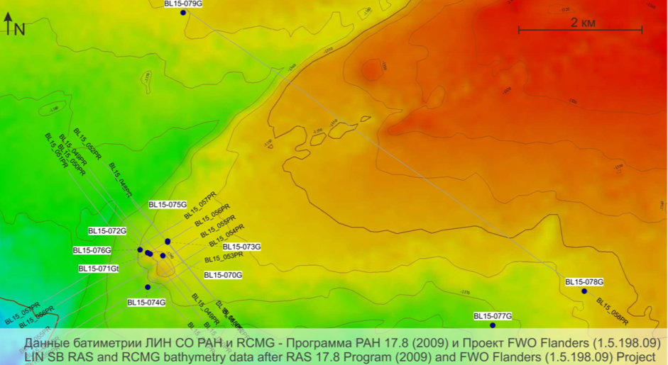
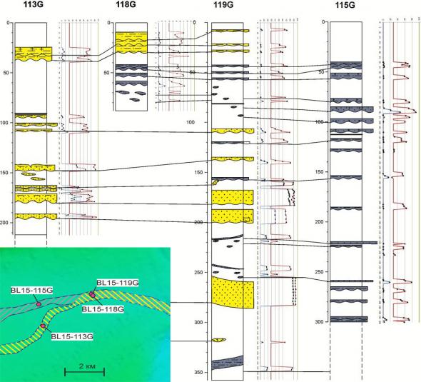
Location of bottom sampling sites and subbottom profiler lines carried out during the Class@Baikal-2015 expedition in the Area «Bolshoy»
Description of the object:
The Bolshoy mud volcano is located at the southern deep of the lake. The volcano is connected with a fault system. It has a complex morphology with two main craters and a possible series of subsidiary minor ones (Cuylaerts et al., 2012; Ахманов, Хлыстов, 2015). According to the available bathymetric data, the diameter of the base of the structure is 1,1 km. The feeder channel is identified as a “blanking” zone on the seismic profiles. The borders of the feeder channel with the surrounding horizontally layered reflectors of ordinary bottom sediments are quite abrupt (Cuylaerts et al., 2012). An assumed BSR pinches out towards the mud volcano edifice.
Research objectives:
Integrated geological and geochemical studies initiated in the Class@Baikal-2015 cruise will be continued. Basing on geophysical data acquired in 2015, intensive bottom sampling is planned in order to characterize peculiarities of mud volcanic deposition and fluid discharge across the edifice of the mud volcano. Special attention will be paid to layers of turbitides, which abundance on underwater high seems to be unusual and requires an explanation. Terrigenous material, which composes such layers, is believed to be periodically transported from flanks of the lake deep. Detailed study of mineral composition of these layers will be focused on distinguishing of sources of the material. Intervals of the deposits of different origins (mud volcanic breccia, turbidites, slumps, lacustrine pelagic, etc.) will be correlated between cores collected from the different parts of the structure. It should help in understanding of an evolution of the mud volcano in relationship to regional geological processes. It is also planned to make bottom sampling along profiles “from the mud volcano edifice toward and across surrounding depressions”. This “profiling” aims to characterise a siliciclastic material distribution pattern within recent depositional basins.
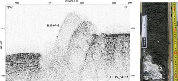
The profiler line across the Bolshoy mud volcano with the location of one of the sampling sites and the photo of a fragment of recovered deposits with gas hydrates
References:
Van Rensbergen P., De Batist M., Klerkx J., Hus R., Poort J., Vanneste M., Granin N., Khlystov O., Krinitsky P. (2002) Sublacustrine mud volcanoes and methane seeps caused by dissociation of gas hydrates in Lake Baikal. // Geology. 2002, v. 30, № 7, pp. 631-634.
De Batist M., Klerkx J., Van Rensbergen P., Vanneste M., Poort J., Golmshtok A., Kremlev A., Khlystov O., Krinitsky P. (2002) Active Hydrate Destabilisation in Lake Baikal, Siberia? // Terra Nova. 2002; v. 14, № 6, pp. 436-442.
Хлыстов О.М. (2006) Новые находки газовых гидратов в донных осадках озера Байкал // Геология и Геофизика. 2006, Т. 47, № 8, с. 979-981.
Cuylaerts M.,, Naudts L., Casier R., Khabuev A.V., Belousov O.V., Kononov E.E., Khlystov O.M., De Batist M. (2012) Distribution and morphology of mud volcanoes and other fluid flow-related lake-bed structures in Lake Baikal, Russia. // Geo-Marine Letters. 2012, v. 32, № 5, pp. 383-394.
Vidischeva, O., Akhmanov, G., Khlystov, O., and Gilyazetdiniva D. (2016). Hydrocarbon gases in baikal bottom sediments: preliminary results of the second international class@baikal cruise. In EGU General Assembly 2016, EGU2016-8204, volume 18 of Geophysical Research Abstracts.
Ахманов Г.Г., Хлыстов О.М., участники TTR-Class@Baikal-2015. (2015) Проект Glass@Baikal: развивая традиции Международной программы "Обучение-через-исследования (Плавучий Университет)". В сб.: Труды IV Международной научно-практической конференции "Морские исследования и образование (MARESEDU)", 19-24 октября 2015 г., Москва, Ломоносовский корпус МГУ. - Москва: Феория, 2015. - с. 29-33
Area 2. Seep and underwater landslide «Krasny Yar»
Previous studies and description of the object:
Several seepage (focused hydrocarbon fluid discharge on a floor) structures were discovered during a geophysical survey in the delta front of the Selenga River in 2007 and named commonly “Krasny Yar”. On side scan sonar record they were characterized by abnormal strong backscatter. These structures are in the depth interval 740-780 meters and their sizes are approximately 425х500, 200х880 and 210х460 meters. Gas-bearing feeder channels were imaged on profiler records. The first geological sampling campaign for «Krasny Yar» structures was conducted in 2012.
If analyzed precisely, multibeam echosounder data acquired in 2009 can show that there is a well-expressed escarpment nearby seepage structures upward along the flank of the lake deep. The scarp is located in the depth intervals of 360-380 m and it is characterized by gently curved shape in planar view. For the first time a slump origin was hypothesized for this scarp during the preparation of the Class@Baikal-2015 expedition. An amphitheatre-shaped scour can be recognized on multibeam data downslope from the escarpment.
Location of bottom sampling sites and subbottom profiler lines carried out during the Class@Baikal-2015 expedition in the Area «Krasny Yar»
Class@Baikal-2015 expedition has conducted comprehensive geo-surveys, which allowed studying the Krasny Yar seeps and the slump complex in detail for the first time (Ахманов, Хлыстов, 2015). Sidescan sonar data did not reveal changes in the high backscatter area associated with the seeps from the last survey conducted several years ago, suggesting that morphology of the area remained the same. Seabed samples aimed at studies of pore water chemistry and the heat flow measurements were taken from central and peripheral parts of the seeps area. Measurements of heatflow within the structures indicated its anomalous character, higher than of the average of the Baikal Lake (Poort et al., 2015). Measurements taken along the periphery of the structures, on the contrary, showed lower than the average values. Seabed sampling has fully confirmed the hypothesis that the high level of the backscatter within the seeps area is caused by the presence of gas hydrates (Хабуев и др., 2015). Slumped sediments and the associated amphitheater scour were mapped during the expedition on the basis of the sidescan sonar and the hull-mounted profiler data. Sidescan sonar data indicated that the seabed scarp has steep walls. Analysis of the data collected during the Class@Baikal-2015 research cruise implies that a propagation of the slumped sediments had been stopped by a seabed ridge of currently unknown origin. At the north the ridge is breached and the slumped material funnels out through a narrow opening spreading down the slope by gravity flows of different types. The new data brought to us many new questions to investigate.
.
Profiler line across slump amphitheater in the area “Krasny Yar” with location of some stations of bottom sampling, carried out during the Class@Baikal-2015 expedition
Research objectives:
During the expedition it is planned to continue the investigations initiated in previous research cruises, to collect new data to be added to the data-base for this object. Among the research objectives is to perform geological sampling of bottom sediments, gas and interstitial water both within and beyond the areas with high backscatter. With heat-flow sensors, which are installed on the gravity core, the in situ measurements of the temperature in bottom sediments will be continued. In addition, it is planned to sample bottom sediments within the slump amphitheater, within the scour, on the seabed ridge downslope, in the “funnel”, and downslope from the “funnel”. Collected material will be studied in the laboratory of tomographic methods of the Moscow State University. An analysis of structure and composition of collected samples will allow understanding of an evolution and, probably, cause and triggers of slumping event in the “Krasny Yar” area. It will be also very interesting to compare the “Krasny Yar” slump with the slump of the Kukuy Griva, which was investigated before during Class@ Baikal expeditions (Solovyeva et al., 2016)
References:
Хабуев А.В., Белоусов О.В., Ченский Д.А., Соловьева М.А., Ченский А.Г., Ахманов Г.Г., Хлыстов О.М. (2015) Геофизические поисковые признаки придонных газовых гидратов озера Байкал: на примере сипа «Красный Яр» В сб.: Труды IV Международной научно-практической конференции "Морские исследования и образование (MARESEDU)", 19-24 октября 2015 г., Москва, Ломоносовский корпус МГУ. - Москва: Феория, 2015. – с. 381-382
Ахманов Г.Г., Хлыстов О.М., участники TTR-Class@Baikal-2015. (2015) Проект Glass@Baikal: развивая традиции Международной программы "Обучение-через-исследования (Плавучий Университет)". В сб.: Труды IV Международной научно-практической конференции "Морские исследования и образование (MARESEDU)", 19-24 октября 2015 г., Москва, Ломоносовский корпус МГУ. - Москва: Феория, 2015. - с. 29-33
Poort J., Khlystov O.M., Akhmanov G.G., Davletshina D., Khabuev A.V., Belousov O.V. & Class@Baikal team. (2015) Lake Baikal seeps and mud volcanoes: what can we learn from thermal data in the sediments? В сб.: Труды IV Международной научно-практической конференции "Морские исследования и образование (MARESEDU)", 19-24 октября 2015 г., Москва, Ломоносовский корпус МГУ. - Москва: Феория, 2015. - с.20-21.
Solovyeva, M., Akhmanov, G., Starovoitov, A., Khlystov, O., Khabuev, A., Chensky, A., Mazzini, A., Tokarev, M., and Gilyazetdinоva, D. (2016). Mass transport on the slope of Кukuy Griva of Lake Baikal: results of the TTR-Class@Baikal expeditions in 2014 and 2015. In EGU General Assembly 2016, EGU2016-8182, volume 18 of Geophysical Research Abstracts.
Area 3. «St. Petersburg» seepage zone
Previous studies and description of the object:
In 2002 during a side-scan sonar survey of the bottom of the middle Baikal depression (SONIC group, St. Petersburg) and seismic profiling (geophysical team from the Institute of Petroleum Geology and Geophysics SB RAS, Novosibirsk) a positive structure, which are associated with a scarp well-defined in bottom topography, was mapped. The structure was named “Saint-Petersburg”.
The detailed study has been conducted for the north-eastern part of the structure. An intensive gas seep of the «flare»-type, which is clearly identified on acoustic profiles, was discovered there (Granin et al., 2010). In 2009 the accumulation of near-surface gas hydrates was found by DSV «MIR» near the gas seepage in the same area (Egorov et.al., 2009). In 2014 during the joint Russian-Japanese research expedition the south-western part of the structure was investigated. During the cruise the samples of gas hydrates from a seep at the base of the scarp were obtained. Within the seepage area «St. Petersburg» mud volcanic deposits have never been sampled until 2015. According to bottom sampling attempts with the gravity corer, the geological section is represented by gas-bearing diatom ooze with thin interlayers of clay, interlayers and lenses of sand and silt (probably, turbidites) with occasional inclusions of carbonates.
The St.Petersburg mud volcano has complex morphology and is located along a fault zone, which is believed to control their origin (Cuylaerts et al 2012). Side-scan sonar and subbotom profiler data were acquired in the area along with the seabed samples during the Class@Baikal-2015 expedition. The data have confirmed the hypothesis of the blocky structure of the area hosting mud volcanoes. Deposits containing dense compacted clays, silts and fine-grained sands and preliminary interpreted as mud breccia were collected from St. Petersburg mud volcano for the first time (Ахманов, Хлыстов, 2015).
The mud volcano is located partially along the hanging wall and partially along the foot wall of a fault block. Mud volcano shows evidence of a vertical material transport, including sediment and fluids, within feeder channels, which developed on both sides of the fault zone. The fault seems to be separating the mud volcano area into different clusters. No heat flow measurements were taken from the St. Petersburg MV due to the presence of coarse-grained sediments and gas hydrates which severely limited the penetration of the gravity corer. Heat flow measurement taken along the periphery of the mud volcano showed normal temperature gradient with depth (Poort et al., 2015).
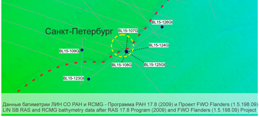
Location of bottom sampling sites and subbottom profiler lines carried out during the Class@Baikal-2015 expedition in the Area «Saint-Petersburg» (red dashed line = tectonic escarpment; yellow dashed line = the “Saint-Petersburg” area)
Sampling data also have confirmed that the lower part of the St. Petersburg mud volcano system is much more active nowadays than the upper part located at the foot wall (Ахманов, Хлыстов, 2015; Vidischeva et al., 2016). In general, the following hypothesis has been proposed to explain the unusual setting and morphology of the St. Petersburg mud volcano (and closely located, very similar Novosibirsk mud volcano). It is believed that initially a large fault system crossing the central part of the lake did not have significant vertical offset but nevertheless initiated mud volcanic activity at certain locations along its extend. The early active mud volcanoes had usual symmetric morphology. The vertical offset of the fault system took place later and this resulted in formation of the currently observed blocky asymmetry. The fault system still supports the activity of the mud volcanoes and it is expected that the vertical movements occur nowadays too (Akhmanov et al., 2016).
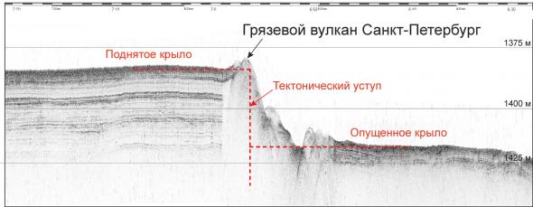
Acoustic profile across the Saint-Petersburg mud volcano carried out during the Class@Baikal-2015 expedition
Research objectives:
During the Class@Baikal-2016 expedition the investigation will be continued and focused within the St. Petersburg structure on mapping and bottom sampling of near-surface gas-hydrate accumulations and deposits with characteristics similar to mud volcanic ones. Measurements of a heat flow are planned to be conducted. It seems interesting to investigate the nature of sand deposits, to define the source and analyze the directions and distances of the clastic material transportation. New material shall allow continuation of very promising and intriguing research started with the data collected in previous Class@Baikal cruises. The origin of the St. Petersburg structure is still very debatable question, which is planned to be solved during Class@Baikal.
References:
Cuylaerts M.,, Naudts L., Casier R., Khabuev A.V., Belousov O.V., Kononov E.E., Khlystov O.M., De Batist M. (2012) Distribution and morphology of mud volcanoes and other fluid flow-related lake-bed structures in Lake Baikal, Russia. // Geo-Marine Letters. 2012, v. 32, № 5, pp. 383-394.
Ахманов Г.Г., Хлыстов О.М., участники TTR-Class@Baikal-2015. (2015) Проект Glass@Baikal: развивая традиции Международной программы "Обучение-через-исследования (Плавучий Университет)". В сб.: Труды IV Международной научно-практической конференции "Морские исследования и образование (MARESEDU)", 19-24 октября 2015 г., Москва, Ломоносовский корпус МГУ. - Москва: Феория, 2015. - с. 29-33
Poort J., Khlystov O.M., Akhmanov G.G., Davletshina D., Khabuev A.V., Belousov O.V. & Class@Baikal team. (2015) Lake Baikal seeps and mud volcanoes: what can we learn from thermal data in the sediments? В сб.: Труды IV Международной научно-практической конференции "Морские исследования и образование (MARESEDU)", 19-24 октября 2015 г., Москва, Ломоносовский корпус МГУ. - Москва: Феория, 2015. - с.20-21.
Vidischeva, O., Akhmanov, G., Khlystov, O., and Gilyazetdiniva D. (2016). Hydrocarbon gases in baikal bottom sediments: preliminary results of the second international class@baikal cruise. In EGU General Assembly 2016, EGU2016-8204, volume 18 of Geophysical Research Abstracts.
Akhmanov, G., Khlystov, O., Mazzini, A., Poort, J., and Giliazetdinova, D. (2016). The class@baikal project: studying recent tectonics, sedimentology and geochemistry on lake baikal. In EGU General Assembly 2016, EGU2016-8110, volume 18 of Geophysical Research Abstracts.
Area 4. The Khuraу deep-water depositional system
Previous studies and description of the object:
The recent erosional incision, which cuts a tectonic scarp on the bottom of Baikal Lake in front of the Tashkiney valley (“Tashkiney paad’” in Russian) of Olkhon Island, is well expressed on the detailed bathymetric map of the middle depression of the Lake Baikal, which has been compiled as a result of RAS Program 17.8 (2009) and FWO Flanders project (1.5.198.09) (http://lin.irk.ru/multibeam/ru/). This structure was crossed with one of the lines of high resolution side-scan sonar (SSS) survey conducted in 2002 in the framework of Russian-Belgian geophysical expedition (INTAS project).
Geological investigation has started in 2014 during the Class@Baikal expedition (Ахманов и др., 2014). The geological section revealed with gravity core sampling in the axial part of the canyon is characterized by a wide-spread slump deposits overlaid by turbitides, which is quite typical for canyons of deep-water fan systems. At the base of the canyon the cores recovered sand, silt and clay intervals with significantly varying thicknesses, which is typical for deep-water fan lobes.
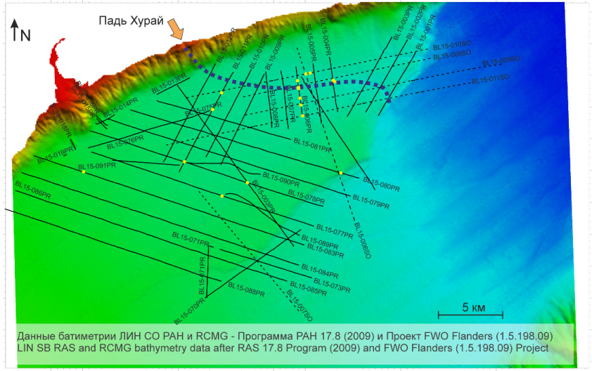
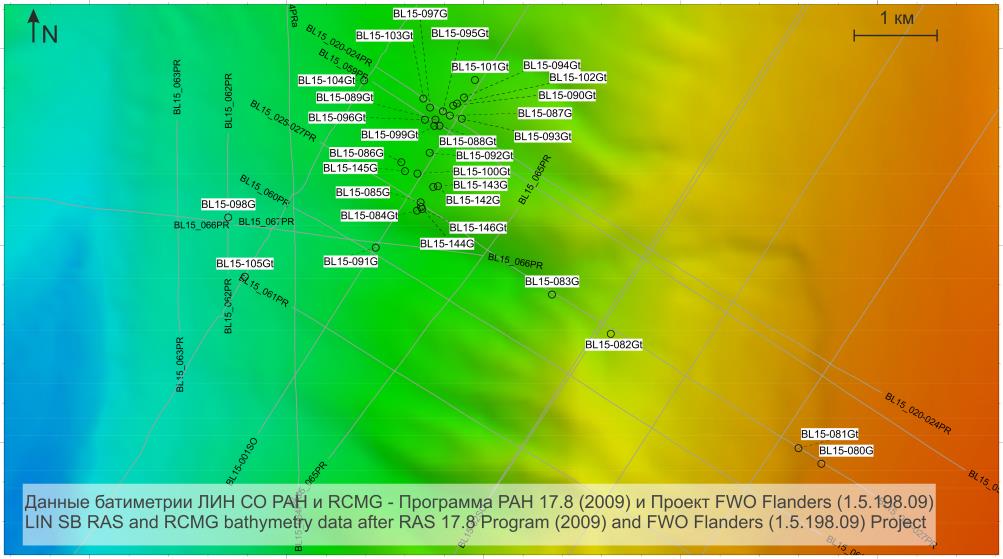
Location of bottom sampling sites and geophysical survey lines carried out during the Class@Baikal-2015 expedition in the Area «Khuray» (blue dashed line = location of Khuray channel assumed before the works started; black lines = profiler lines; black dashed lines = side scan sonar lines)
During the expedition Class@Baikal-2014 it was noticed that the upper part of the studied canyon is connected with the elongated channel that is also expressed on the detailed bathymetric map. The core taken from this channel was represented by typical sediments of the distal part of deep-water channel. The common origin (belonging to the same sedimentary system) of the channel and the canyon was entirely proved during the study of the collected samples. During the very first interpretation of the data, yet onboard, the channel was traced in the bottom relief of Baikal Lake up to Khuray-Khylzyn valley of Olkhon Island. In accordance with names of well-known deep-water sedimentary systems those are named after the main source of terrigenous material (e.g. Kongo deep-sea fan, Rona deep-sea fan, Amazon fan, etc.) the participants of Class@Baikal-2014 expedition named the discovered system «Khuray deep-water fan» and its elements – «Khuray channel» and «Khuray canyon» respectively (Ахманов и др., 2014). The work was continued, and in the Class@Baikal-2015 expedition it became clear that this system is much more complex than it seemed before (Ахманов, Хлыстов, 2015). Clastic material within the system is gathered from both flanks of the central Baikal deep and then transported by gravity flows of different types for considerable distance to the northeast where it is deposited with depositional terminal lobes. The presence of the deeply incised valley in the distal part of this system is unusual and makes it different from a typical deep-water fan.
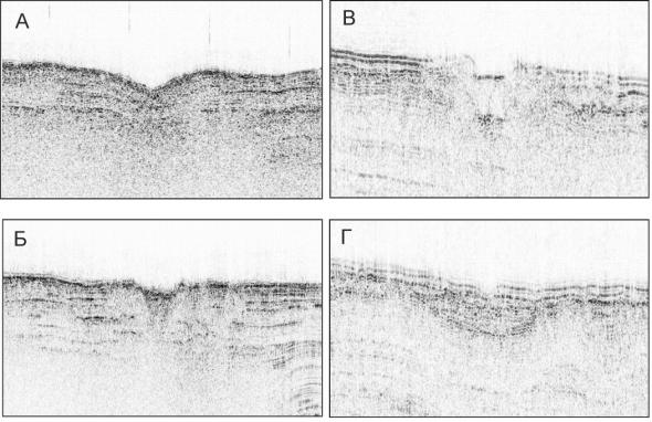
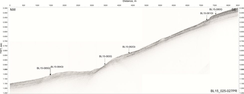
Different types of channels, distinguished in accordance with different characteristics of acoustic record obtained with profiler survey carried out in the area “Khuray” during Class@Baikal-2015 expedition
2015 studies were focused on the central part of the system located immediately above the valley and aimed at understanding of facies distribution within the transit part of the system. The transit part is confined by the step flanks of the deep from the northwest and by extensive fault block from the southeast. The seabed expression of this block increases to the northeast. Significant portion of the Baikal seabed was covered by side-scan sonar survey and seabed samples were collected at key locations. Preliminary analysis of the data allows to identify in the study area three major facies zones which follow each other along the main clastic sediments transport direction (Akhmanov et al., 2016). At the proximal part of the study area the seabed has a gentle slope gradient dipping toward the center of the deep. The seabed is dominated by a system of multiple small unconfined channels without a preferred direction. No main feeder channel has been established and it is believed that all of the channels are of the same rank. Downslope this zone is followed by a system of two relatively large channels running in sub-parallel direction. The seabed morphology resembles a gentle valley with significant flank asymmetry. One of the channels runs along the thalweg of the valley leaning to the fault block edge. The other channel leans toward the slope of the deep running along gently dipping flank of the valley. Both channels undoubtedly represent the main clastics fairways of this portion of the system. Smaller channels, similar to those in the updip zone, were also noticed on the seabed. Since the main channels are located at different depth levels it is believed that sediments could be transported between them through the lesser ones. The above channels merge into one in the next downdip zone adjacent to the canyon-like valley. The axis of the valley migrates towards the slope of the deep where it becomes more expressed onto the seabed and the small channels disappear. In general it is believed that most of the sediments are gathered from the extensive slopes and large area at the bottom of the Lake’s central deep (Почевалова и др., 2016). The sources of clastic material, specifics of its mobilisation and transportation and the ongoing changes of the depositional system morphology are controlled by the active modern day tectonics of the area.
An example of turbidite laminae correlation between the cores collected during the Class@Baikal-2015 expedition in the Kuray deep-water depositional system. Coring sites location is on inset. Turbidites of southern channel are marked in yellow, turbidites from the north are in grey.
Research objectives:
During the Class@Baikal-2016 expedition the distal part of the Khuray deep-water system with its lobes will be sampled in the area below the Khuray canyon, to the east from the tectonic scarp. Obtained data will add to a picture of recent sediment distribution in this part of Baikal deep.
References:
Ахманов, Г. Г., Хлыстов, О. М., Токарев, М. Ю. и участники Class@Baikal-2014 (2014). Первая экспедиция Байкальского Плавучего Университета: современное осадконакопление и зоны фокусированной разгрузки углеводородов и газогидратообразования на дне озера. В сб. Материалы III Международной молодежной научно-практической конференции "Морские исследования и образование" (Москва, 22-24 октября 2014 г.), с. 19–23. Москва.
Ахманов Г.Г., Хлыстов О.М., участники TTR-Class@Baikal-2015. (2015) Проект Glass@Baikal: развивая традиции Международной программы "Обучение-через-исследования (Плавучий Университет)". В сб.: Труды IV Международной научно-практической конференции "Морские исследования и образование (MARESEDU)", 19-24 октября 2015 г., Москва, Ломоносовский корпус МГУ. - Москва: Феория, 2015. - с. 29-33
Akhmanov, G., Khlystov, O., Mazzini, A., Poort, J., and Giliazetdinova, D. (2016). The class@baikal project: studying recent tectonics, sedimentology and geochemistry on lake baikal. In EGU General Assembly 2016, EGU2016-8110, volume 18 of Geophysical Research Abstracts.
Почевалова, А. В., Ахманов, Г. Г., Хлыстов, О. М., Корост, С. Р., and Соловьева, М. А. (2016). Особенности осадконакопления глубоководной осадочной системы Хурай озера Байкал. В сб.: Тезисы Всероссийской научно-практической молодежной конференции «Современные исследования в геологии» 25-27 марта 2016 г,. СПбГУ ИТМО СПб. с. 202–203.
Area 5. Underwater continuation of Tankhoy Field
It is a new for Class@Baikal and the largest area of the Third expedition. It extends on the eastern flank of the southern deep of Baikal Lake from the underwater high Murino Bank to mouth of Pereemna River (Tankhoy railway station). The area is, in fact, a underwater continuation of, so called Tankhoy Field, Oligocene-Miocene coal-bearing series outcropping on the eastern coast of Baikal Lake. Rocks of Tankhoy Formation lie on weathering crust of the regional basement. Formation of Tankhoy deposits corresponds to one of the earliest stage of Baikal rifting, their stratigraphic analogues are, probably, the oldest sedimentary rocks of Baikal depression (Мащук, Акулов, 2012).
Within the investigation area the bathymetry of Baikal flanks is rather well studied with the help of multibeam echosounder. The flanks are characterized by abundant deep canyons of very complex morphology. These canyons are incised into bedrocks of underwater continuation of Tankhoy Formation and filled with various modern sediments. This suggests, probably, repeated changes in erosion base in the region and reflects very complex geological evolution of the area.
Acoustic geophysical survey and extensive bottom sampling campaign are planned in the area during the Class@Baikal-2016 expedition. The aim is to characterize in details structure and composition of the bedrocks and recent sedimentary infills of the canyons.
Hydrocarbon seepage sites are very abundant in the area as well. These sites were discovered and studied previous cruises. However, a source for discharging fluids is still undetected. Gas generation within relatively thick Tankhoy Formation and its migration to the surface can be assumed. It is planned to collect gas samples and to study them in laboratories of the Moscow State University in order to understand lithology and position of source rocks in sedimentary succession of the Baikal deep, time of fluid generation, nowadays depth of discharging reservoirs, etc.
References:
Мащук И.М., Акулов Н.И. (2012) Олигоценовые отложения Байкальской рифтовой впадины. – Геология и Геофизика, т.53, №4, с. 461-475
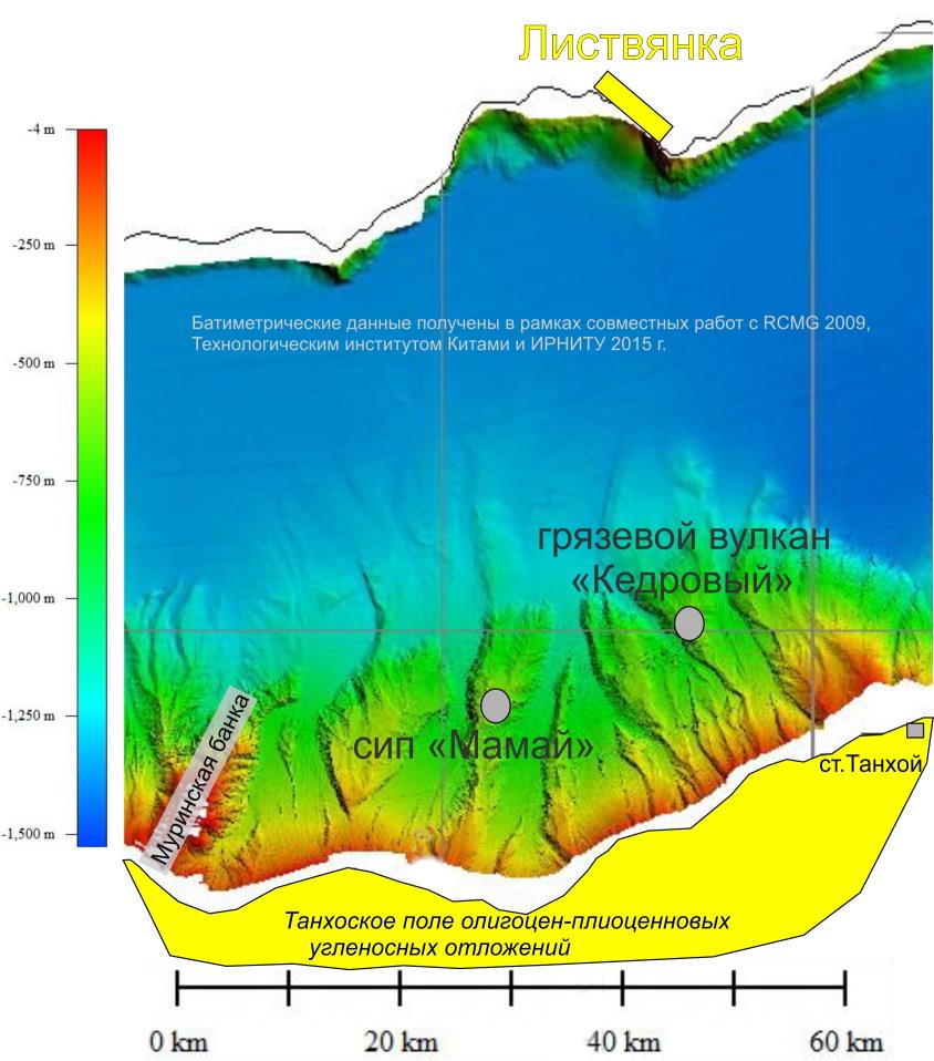
Morphology of the eastern slopes of the south depression of Baikal Lake which will be investigated during the Class@Baikal-2016 expedition in the area «Tankhoy Field»