About the Class@Baikal-2015 expedition
The Second International student's expedition (Class@Baikal) will be carried out during the period from July 8 to July 29, 2015 onboard of the research vessel “G.Yu.Vereshchagin” in the waters of Baikal Lake. In the course of the expedition it is planned to continue investigation of unique natural processes at the bottom of the Baikal Lake. Participants of the expedition will get acquainted with modern methods of geological, geophysical and geochemical studies of bottom sediments, will be trained how to work with the equipment. In the same manner like during the First expedition performed in 2014 every day the participants will prepare and upload on the special website the detailed and illustrated report on the works carried-out during the day. Also during the expedition, daily scientific and training lectures and seminars will be given onboard the ship. All materials of lectures and seminars will appear on our website every day.

Areas of the investigation of the Class@Baikal-2015 expedition
Area 1. The gas seepage area “Goloustnoe”
One of the most studied areas of gas seepage on the bottom of the Lake Baikal is located near the delta of the Goloustnaya river (the southern depression of Baikal). Integrated geological and geophysical studies, including side-scan sonar (SSS) surveys, single-beam and multibeam echo sounding, geological observations from Deep Submergence Vehicles (DSV) «MIR» and geological sampling of bottom sediments have been performed there before (Granin et al., 2010, Hachikubo et al., 2010, Khlystov et al., 2013).
The recent delta front of the Goloustnaya river and the under-water rise to the south-west are located within the study area. The whole area represents a part of an extensive paleo-delta front. At the present moment the sedimentary body of the paleo-delta front is being intensively eroded and the complex system of well-defined and quite extensive canyons is being formed. At the flattened elevated areas and the ridges between the canyons Upper Neo-Pleistocene and Holocene deposits occur. At the slopes of the canyons there are only Lower Pleistocene outcrops. In the gas seepage areas these deposits are commonly cemented by gas-hydrates. On the bottom of the canyons the clastic material of different compositions and ages is identified.

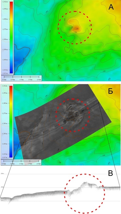
Geomorphological scheme of the “Goloustnoe” seep with locations of focused gas flows the bottom (after Khlystov et al., 2014)
Previous studies
On the slope and on the ridge of the rise active gas seeps have been discovered as acoustic anomalies («flares») on echograms of a single-beam echo sounder. The first seep was discovered in 2007 at the 560 m depth. Due to its peculiar shape it was named «Stupa» (Russian word for a mortar) (Granin et al., 2010). The next founded (in 2008) gas seeps at the depth from 545 m to 345 m were marked with letter «G» and serial number «1», «2», «3», «4» («G» – the first letter of the name of the area «Goloustnoe») (Hachikubo et al., 2010). In the area of the flares G-1, G-2, which occurs deeper than 360 m, layered and lens-shaped gas-hydrate accumulations have been found (Hachikubo et al., 2010, Khlystov et al., 2013).
Two massive and extensive layers of gas hydrates (both are approximately 15 cm thick) were found as outcrops in the flank of the canyon during observations from DSV «MIR» in the area of the gas seep «G-2». The hydrate layers were separated by a 1 meter thick layer of ordinary sediments. Within this area, above the massive hydrate layers, numerous interlayers and lenses of gas-hydrates (significantly thinner) were recovered with gravity corers (Khlystov et al., 2013).
Within the study area a spatial mapping of the depth of the top of the gas-hydrate accumulations was carried out. The survey was conducted using a cone penetrometer. A stress load on a tip of the cone was measured directly when pushing the cone into the ground. This survey enabled to perform mapping of the depths of subsurface gas-hydrates for the first time ever at the Baikal Lake. In the relatively small area a number of near-surface gas-hydrate zones (depth intervals from 0 to 0.5 meters) have been found. Some of these zones are associated with gas-bubbling at the seeps «G-1» and «G-2». The others aren’t associated with current active seeps, but, probably, indicate the areas of quite recent gas seepage (Khlystov et al., 2014).

The depth of gas hydrates in the gas seepage area «Goloustnoe» (after Khlystov et al., 2014)
Research objectives
Up to the moment the thickness of the gas-hydrate layer in the gas seepage area «Goloustnoe» still remains unknown. To figure out this problem a seismic profiling with an air-gun will be performed for the identification of BSR, which coincides with the bottom of a gas-hydrate stability zone.
In the plans of the expedition to conduct a few seismic profiles and perform the integrated geological and geochemical bottom sampling campaign in the study area.
References:
Granin N.G., Makarov M.M., Kucher K.M., Gnatovsky R.Y. Gas seeps in Lake Baikal —detection, distribution, and implications for water column mixing. // Geo-Marine Letters, 2010, v. 30, р. 399 – 409.
Hachikubo, A., Khlystov, O., Krylov, A., Sakagami, H., Minami, H., Nunokawa, Y.,Yamashita, S., Takahashi, N., Shoji, H., Nishio, S.Y., Kida, M., Ebinuma, T.,Kalmychkov, G., Poort, J. Molecular and isotopic characteristics of gas hydrate-bound hydrocarbons in southern and central Lake Baikal // Geo-Marine Letters, 2010, v. 30, р. 321–329.
Khlystov O.M., De Batist M., Shoji H., Hachikubo A., Nishio S., Naudts N., Poort J., Khabuev A., Belousov O.М., Manakov A. Y., Kalmychkov G.V. Gas hydrate of Lake Baikal: Discovery and varieties. // J Asia Earth Sci., 2013, v. 62, р. 162-166.
Khlystov O.M., Nishio Sh., Manakov A.Iu., Sugiiama KH., Habuev A.V., Belousov O.V., Grachev M.A. Opy`t kartirovaniia krovli pripoverkhnostny`kh gazovy`kh gidratov ozera Bai`kal i izvlechenie gaza iz nikh. // Geologiia i geofizika. 2014, т. 55, № 9, с. 1415-1425 (in Russian).
Area 2. The Bolshoy mud volcano
Previous studies
The mud volcano was discovered in 1999 as the result of a bottom side-scan sonar survey that was conducted as a part of the joint Russian-Belgian (INTAS-1915) research project with the assistance from a geophysical research team «SONIC» (St. Petersburg) (Van Rensbergen et al., 2002, De Batist et al., 2002). In 2003 during geological sampling campaign gas hydrates and mud volcanic breccia have been collected from the structure (Khlystov, 2006).
Description of the object
According to the available bathymetric data there are two summits of the Bolshoy mud volcano. One is 18 meters high, another is 25 meters high. The diameter of the base of the structure is 1,1 km. The feeder channel is identified as a “blanking” zone on the seismic profiles. The borders of the feeder channel with the surrounding horizontally layered reflectors of ordinary bottom sediments are quite abrupt. An assumed BSR pinches out towards the mud volcano edifice. The mud volcano is associated with a fault system.
Research objectives
During the expedition integrated geological, geophysical and geochemical studies will be carried out in order to clarify the structure and nature of the mud volcano. To investigate the stratification of subbottom deposits and the peculiarities of fluid seepage regime, high-resolution seismo-acoustic profiler lines will be performed. For the first time ever within the Class@Baikal expeditions, onboard installation of the seismic system with an air-gun source (and seismic observations with this system) is planned. If successful, unique data on the character of BSR distribution and its topography are expected to be obtained. A large amount of geological sampling of the mud volcano itself and pelagic deposits around is planned to be done. The sampling will be conducted using gravity corer with heat-flow sensors. The information on the heat flow will allow to compute the BSR depth. The comparison of the computed BSR depth with the BSR depth acquired from seismic data will clarify all the other factors that impact the BSR formation in the study area. Moreover, geological sampling of mud volcanic deposits for the follow-up age determination of mud-volcano eruptions and erupted material by means of diatom analysis is planned to be performed. As the result of the integrated research the model of this mud volcano should be developed.
The Bolshoy mud volcano
A – bathymetric scheme (according to the data of multibeam survey of 2009 within the project of RAS Program 17.8 and FWO Flanders project 1.5.198.09);
Б – SSS (side-scan sonar) mosaic (2005);
В – profiler line (profiler was installed at SSS), (2005)

The Bolshoy mud volcano
А – perspective view;
Б – profilerline, 2005.;
В – seismic profile, 2002. Interpretation by Cuylaerts M. et al., 2010
References:
1. Van Rensbergen P., De Batist M., Klerkx J., Hus R., Poort J., Vanneste M., Granin N., Khlystov O., Krinitsky P. Sublacustrine mud volcanoes and methane seeps caused by dissociation of gas hydrates in Lake Baikal. // Geology. 2002, v. 30, № 7, pp. 631-634.
2. De Batist M., Klerkx J., Van Rensbergen P., Vanneste M., Poort J., Golmshtok A., Kremlev A., Khlystov O., Krinitsky P. Active Hydrate Destabilisation in Lake Baikal, Siberia? // Terra Nova. 2002; v. 14, № 6, pp. 436-442.
3. Khlystov О.М. Discoveries of gas-hydrates in the bottom sediments of the Baikal Lake// Geologiya I Geofizika. 2006, v. 47, № 8, pp. 979-981 (in Russian)
4. Cuylaerts M.,, Naudts L., Casier R., Khabuev A.V., Belousov O.V., Kononov E.E., Khlystov O.M., De Batist M. Distribution and morphology of mud volcanoes and other fluid flow-related lake-bed structures in Lake Baikal, Russia. // Geo-Marine Letters. 2012, v. 32, № 5, pp. 383-394.
Area 3. Seep «Krasny Yar»
Previous studies
The structures «Krasny Yar - 1», «Krasny Yar - 2» and «Krasny Yar - 3» were discovered during the side-scan sonar (SSS) geophysical survey in the western part of the delta front of the Selenga River in 2007. On sonogram they were identified as 3 anomalous areas with strong backscatter. These structures are in the depth interval 740-780 meters and their sizes are approximately 425х500, 200х880 and 210х460 (meters x meters). For each structure the presumably gas-bearing feeder channels were recorder on profiler lines. Also, as it was documented previously, the area "Krasny Yar - 1" is characterized by gas seepage (Granin et al., 2010). The first geological sampling campaign for «Krasny Yar» structures was conducted in 2012. It was found out that gas hydrates occur only within the contours of the areas of strong backscatter (Khabuev et.al, 2015). In 2009, during the multi-beam survey, a slide body, well-expressed in topography, was identified close to the seepage structures, upslope from them. The main scarp of the slide occurs at the depths from 360 to 380 meters.

The structures of gas seeps on the bottom «Krasny Yar» and slide area on the profiler, side-scan sonar and multibeam data
Research objectives
In 2015 the monitoring SSS survey in the seepage area will be conducted. Moreover, the previously unexplored slide area of the slope will be mapped with SSS. One of the research objectives is to perform geological sampling of bottom sediments, gas and interstitial water both within and beyond the areas with high backscatter. With heat-flow sensors, which are installed on the gravity core, the in situ measurements of the temperature in bottom sediments will be carried out. Seismic profiling will be performed for BSR mapping and investigation of the topography of its surface.
Area 4. Seep «St. Petersburg»
Previous studies
In 2002 within the INTAS project the joint Russian-Belgian geophysical expedition to the Lake Baikal was organized. During a side-scan sonar survey of the bottom of the middle Baikal depression (SONIC group, St. Petersburg) and seismic profiling (geophysical team from the Institute of Petroleum Geology and Geophysics SB RAS, Novosibirsk) two positive structures, which are associated with a scarp well-defined in bottom topography (probably of a tectonic nature) were discovered.
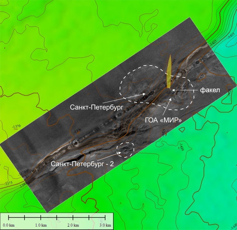
The seepage area «St. Petersburg» with locations of the areas of detailed studies (bathymetric data from the projects of RAS Program 17.8 and FWO Flanders project 1.5.198.09.)
Based on the acquired data an assumption of mud volcanic origin of these structures was made. One of the structures was named «Novosibirsk», the other one – «St. Petersburg». During further studies the assumption of mud volcanic nature of the structure «Novosibirsk» has been entirely proved: quite typical mud volcanic deposits were recovered from this structure by gravity corers, mud breccia flows and near-surface gas-hydrate accumulations were mapped. The mud volcano «Novosibirsk» was among the objects of the investigations of the Class@Baikal-2014 expedition. At this moment the detailed studies of the structure and composition of the mud volcanic deposits of this volcano is carried out in the laboratories of the Moscow State University.
The structure and, probably, the nature of «St. Petersburg» is a far more complicated. The detailed study has been conducted for the north-eastern part of the structure. An intensive gas seep of the «flare»-type, which is clearly identified on acoustic profiles, was discovered there (Granin et al., 2010). In 2009 the accumulation of near-surface gas hydrates was found by DSV «MIR» near the gas seepage in the same area (Egorov et.al., 2009). In 2014 during the joint Russian-Japanese research expedition the south-western part of the structure was investigated. During the cruise the samples of gas hydrates from a seep at the base of the scarp were obtained. The seep was named «St. Petersburg-2». Its size is approximately 500 m in diameter.
It should be noted that within the seepage area «St. Petersburg» (including both investigated parts) mud volcanic deposits have never been sampled. According to bottom sampling attempts with the gravity corer, the geological section is represented by gas-bearing diatom ooze with thin interlayers of clay, interlayers and lenses of sand and silt (probably, turbidites) with occasional inclusions of carbonates.

The 3D model of the seepage area «St. Petersburg»
Research objectives
During the Class@Baikal-2015 expedition the investigation will be focused on the seep «St. Petersburg-2». The bottom sampling campaign and the exploration of near-surface gas-hydrates will be continued. Measurements of a heat flow, a few seismic and acoustic profiles are planned to be conducted. One of the objectives is to establish the genesis of the structure and define the trends of gas-hydrate formation within this structure. It seems interesting to investigate the nature of sand deposits, to define the source and analyze the directions and distances of the clastic material transportation.
Area 5. The Khuraу deep-water depositional system
Previous studies and description of the object
The recent erosional incision, which cuts a tectonic scarp on the bottom of Baikal Lake in front of the Tashkiney valley (“Tashkiney paad’” in Russian) of Olkhon Island, was discovered during previous expeditions. It is well expressed on the detailed bathymetric map of the middle depression of the Lake Baikal, which has been compiled as a result of RAS Program 17.8 (2009) and FWO Flanders project (1.5.198.09) (http://lin.irk.ru/multibeam/ru/). Moreover, this structure was crossed with one of the lines of high resolution side-scan sonar (SSS) survey conducted in 2002 in the framework of Russian-Belgian geophysical expedition (INTAS project). A large incision (canyon) can be identified on SSS data. For the first time ever the bottom sampling of this canyon was performed during the expedition Class@Baikal-2014 organized by the Lomonosov Moscow State University (MSU) and LIN SB RAS in summer 2014.

General scheme of the location and structure of the Khuray deep-water sedimentary system
Eight bottom sampling stations were taken, using 3 meter long gravity corer. The geological section revealed in the axial part of the canyon is characterized by a wide-spread slump deposits overlaid by turbitides, which is quite typical for canyons of deep-water fan systems. Fine intercalation of clay, silt and sand laminae with well-pronounced graded lamination was to be typical for the both flanks of the canyon, characterizing the deposition on levees and overbanks. At the base of the canyon the cores recovered sand, silt and clay intervals with significantly varying thicknesses, which is typical for deep-water fan lobes. During the expedition Class@Baikal-2014 it was noticed that the upper part of the studied canyon is connected with the elongated channel that is also expressed on the detailed bathymetric map. The core taken from this channel was represented by typical sediments of the distal part of deep-water channel. The common origin (belonging to the same sedimentary system) of the channel and the canyon was entirely proved during the study of the collected samples.
The channel can be traced in the bottom relief of Baikal Lake up to Khuray-Khylzyn valley of Olkhon Island. Apparently, the whole sedimentary system is associated with the supply of clastic material from this valley. In accordance with names of well-known deep-water sedimentary systems those are named after the main source of terrigenous material (e.g. Kongo deep-sea fan, Rona deep-sea fan, Amazon fan, etc.) the participants of Class@Baikal-2014 expedition named the discovered system «Khuray deep-water fan» and its elements – «Khuray channel» and «Khuray canyon» respectively. The difference between «classical» deep-water fans and the discovered system in Baikal is that there is the second canyon with a very specific location (between the channel and the fan lobes but not only before channel as usual), which is associated with a neo-tectonic scarp on the bottom of the Lake Baikal.

3D view of the distal zone of the Khuray deep-water sedimentary system (distal part of the channel, the canyon and the sedimentary lobes) investigated during the Class@Baikal-2014 expedition. SSS profile (2002), location of the sampling stations (2014), and detailed bathymetry data (RAS Program 17.8 (2009) and FWO Flanders project (1.5.198.09))
Research objectives
During the Class@Baikal-2015 expedition the investigation of the discovered Khuray structure will be continued. The survey of the middle and distal parts of the Khuray channel (zone of transit of clastic material) and sedimentary lobes (zone of main accumulation) is planned to be done. Integrated studies with onboard profiler and bottom sampling will be carried out. The acquired data should become the basis for mapping of current sedimentary facies and should clarify the processes and trends in transportation, distribution and accumulation of detrital material within deep-water structures developing in tectonically active areas.