About Expedition 2022
The 5th year anniversary International expedition of the Class@Baikal project will take place on Lake Baikal from June 20th to July 7th, 2018. Scientific investigations will be carried out on board the research vessel “G. Yu. Vereshchagin”.
Students, teachers and scientists of the Lomonosov Moscow State University will participate to the expedition along with the scientists of the Limnological Institute of the SB RAS and the University of Oslo (Norway).
The expedition will continue the "Training-through-Research" cycle of studies focused on unique natural geological processes at the bottom of Lake Baikal. New participants will acquire the practical knowledge in modern methods of geological-geophysical and geochemical studies of the bottom layers. They will also learn techniques for data acquisition and equipment deployment throughout the expedition. Students who previously participated in the Class@Вaikal projects in 2014-2017 will continue their dedicated studies on selected topics and areas of interest. Daily lectures and seminars related to the marine expedition and similar topics will be held on board of the vessel.
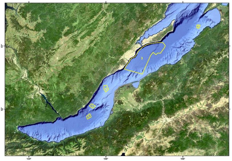
Areas of investigations of the Class@Baikal-2018 expedition
Area 1. "Elovsky"
The "Elovsky" area is located in the northern part of the southern basin of Lake Baikal. Profiler and side-scan sonar surveys were carried out in this area in 2007-2008 (Limnological Institute of the SB RAS) revealing the presence of unique positive structures in the profiler data.
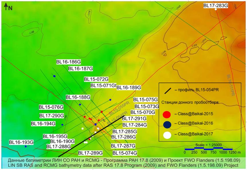
Integrated geological and geophysical surveys were carried out during the international expedition Class@Baikal-2015 including subbottom profiling and sediment sampling. 19 profiles were collected in the area of work in 2015, targeting general study of the area and anomalous features.
Location of bottom sampling sites and subbottom profiler lines carried out during the Class@Baikal-2015 expedition in the «Elovsky» area (Ахманов и др.,.2015)
Two types of structures characterize the area.
The fist type is imaged on the seismic record by low-amplitude hyperbolic reflections located above the bottom lake floor. These objects correspond to positive features 300-500 meters wide and 10 to 25 meters high. These features are sometimes confined by faults. Interestingly some of these structures are characterized by positive relief on acoustic data as well as negative relief on the multi-beam echo sounder data.
The second type of structures appears on the seismic record as vertical zones with loss of correlation below the bottom reflector. These structures are concentrated in the eastern part of the "Elovsky" area.
Seismoacoustic profile across the “Elovsky” area structures obtained during the Class@Baikal-2015 expedition (Ахманов и др., 2015)
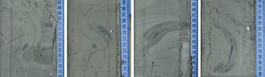
Bottom sampling retrieved sequences characterized by clayey-diatom silt, clayey silt and silty-clay intervals, typical for modern lake bottom sediments. Atypical or "anomalous" sediments were retrieved only at one station where very dense, dry silty clay was found in the upper part, overlaying interbedded clayey and dense silty-clay with numerous mica flakes.
Objects of the 1st type (red areas) and the 2nd type (yellow areas), delineated at the "Elovsky" area (Буланова и др., 2018)
Class@Baikal-2018 Expedition objectives:
Investigation of the origin of structures discovered in previous missions within the "Elovsky" polygon. New study includes additional seismoacoustic survey using sparker source and geological sampling.
Class@Baikal-2018 Expedition objectives:
Investigation of the origin of structures discovered in previous missions within the "Elovsky" area is planned. The new study includes additional seismic surveys using sparker source and geological sampling.
References:
Ахманов Г.Г., Хлыстов О.М. и участники TTR-Class@Baikal-2015. (2015) Проект Glass@Baikal: развивая традиции Международной программы "Обучение-через-исследования (Плавучий Университет)" // Сб.: Труды IV Международной научно-практической конференции "Морские исследования и образование (MARESEDU)". – М.: Феория, 2015. – С. 29-33.
Буланова И.А., Соловьева М.А., Ахманов Г.Г. (2018) Предварительные результаты геолого-геофизических исследований полигона Еловский (озеро Байкал). // // Материалы Международного молодежного научного форума «ЛОМОНОСОВ-2018» / Отв. ред. И.А. Алешковский, А.В. Андриянов, Е.А. Антипов. [Электронный ресурс] — М.: МАКС Пресс, 2018.
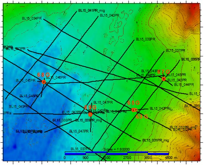
Area 2. "Gorevoy Utyos"
One of the most studies areas with ongoing hydrocarbons seepage is located at the bottom of Lake Baikal on the traverse of the cape Gorevoy Utyos. This zone is characterized by oil and gas outbursts accompanied by near-surface accumulations of gas hydrates (Каширцев и др., 2006; Конторович и др., 2007; Хлыстов и др., 2007; Хлыстов и др., 2009). This setting is unique since displays the simultaneous emission of gaseous and liquid hydrocarbons combined with the presence of gas hydrates in a restricted area. The active seepage area is about 500 m in diameter and located on a slope at a depth interval ranging between 850-950 m.
Class@Baikal-2018 Expedition objectives:
1. High resolution seismic survey of seepage zone (two orthogonal profiles)
2. Bottom sampling along the seismic profiles to obtain gas, pore water and bituminous sediments to be analysed in the MSU laboratories. Six stations are planned within the seepage zone. 16 additional stations will be targeted at 200, 500, 1000 and 2000 m away from seepage site in four different directions.
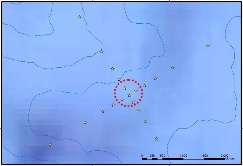
Schematic map of the position of the planned stations for bottom sampling (yellow stars) along two profiles crossing the zone of the active seepage "Gorevoy Utyos” (outlined by a red intermittent line)
One of the aims is to assess spatial influence of focused seepage on geochemical characteristics of surrounding sediments. Geochemical methods and parameters sensitive to such influence will be defined during this study. The results of the investigation on the ”Gorevoy Utyos” area will be applicable to a wide range of marine geochemical settings where focused seepage occur. More specifically, it will be useful for defining the offset in marine geochemical surveys and post-survey laboratory analysis.
References:
Каширцев В.А., Конторович А.Э., Москвин В.И., Данилова В.П., Меленевский В.Н. (2006) Терпаны нефтей озера Байкал//Нефтехимия, 2006, том 46, №4, С. 1-9
Конторович А.Э.,Каширцев В.А., Москвин В.И., Бурштейн Л.М., Земская Т.И., Костырева Е.А., Калмычков Г.В., Хлыстов О.М. (2007) Нефтегазоносность отложений озера Байкал Геология и геофизика, 2007, т.48, №12, с. 1346-1356
Хлыстов О.М., Горшков А.Г., Егоров А.В. и др. (2007) Нефть в озере Мирового наследия / Доклады академии наук, 2007, том 414, №5, с. 1-4.
Хлыстов О.М., Земская Т.И., Ситникова Т.Я и др. (2009) Донные битумные постройки и населяющая их биота по данным обследования озера Байкал с глубоководных обитаемых аппаратов «Мир»/ Доклады академии наук, 2009, том 428, №5, с. 1-4.
Area 3. The Khuraу deep-water depositional system
Research history and description of the object:
The area 3 targets a depositional system located in the central basin of Lake Baikal and to the southeast of Olkhon Island at depths more than 1000 m. The initial investigations on the area were carried out during the 2002 Russian-Belgian expedition (INTAS project) when side-scan sonar profiles were run across incision in tectonic scarp. This NE-SW oriented tectonic escarpment divides the basin. Additional bathymetry survey was conducted during the RAS Program 17.8 (2009) and the FWO Flanders project (1.5.198.09). However, a systematic study of the area began only in 2014 with the start of Class@Baikal expeditions.
Erosion channel cut in the tectonic scarp on the bathymetry data and the Side Scan Sonar data. The blue arrows indicate the first sampling sites made during the expedition Class@Baikal-2014 (Ахманов и др., 2014)
The first sampling was completed in the axial part of the deep-water canyon, recovering a 3 m long sedimentary sequence of alternating slumped and turbiditic deposits typical for canyon systems and deep-water fans. Sandy, silty and clayey intervals of various thickness (typical for sedimentary lobes) were found at the base of the canyon.
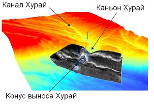
Bathymetry data interpretation indicates that the canyon is connected in its top to a distinct channel. The sediments collected in the channel recovered a typical succession of channels in distal part of deep-sea depositional systems. Combining the acquired data, a common origin of the channel and the canyon was distinguished. The connection between the underwater canyon and the onshore Khuray valley was observed on the bathymetry data. Similarly to other known sedimentary systems (e.g. Kongo and Amazon deep-sea fan, etc.), also this one was named after of the main onshore source, hence the name “Khuray deep-water fan”. The main features of this system were accordingly named as: Khuraу canyon, Khuraу channel, etc. (Ахманов и др., 2014).
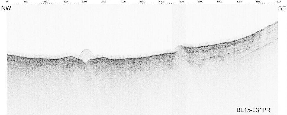
The structure of the middle part of this sedimentary system was studied during the Class@Baikal-2015 expedition with geophysical methods (Ахманов и др., 2015]. Results revealed that the structure of the channel system is much more complicated than expected. The Khuraу valley is not the main sediment source. Large part of the channel system was surveyed using sidescan sonar, subbottom profiler and bottom sampling. Subbottom profiles showed the presence of numerous channels characterized by various types of acoustic pattern. Recent small channels are emplaced above larger filled palaeo channels.
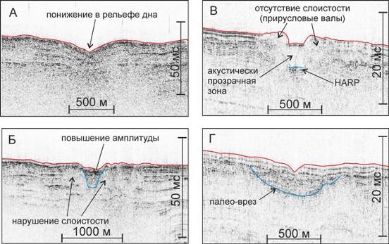
Different types of channels, distinguished in accordance with different characteristics of acoustic record obtained with profiler survey carried out in the area “Khuray” during the Class@Baikal-2015 expedition
The central part of the Khuraу sedimentary system is characterized by a complex structure of converging and branched small channels. Here the bathymetry is almost flat gently dipping towards the northeast and gradually taking the form of the plain with two asymmetrical boards.
Approaching the Khuraу canyon all the channels converge in a single one (Ахманов и др., 2015).
Acoustic data collected from the distal part of the system allowed distinguishing lobe deposits covered with sediments up to a depth of 50 m bsf. According to Evangelinos et al., (2017) during the Late Pleistocene the area has been characterized by average sedimentation rates of ~75 cm per thousand years. These values suggest that the Khuray sedimentary system has been active for at least 70000 years (Соловьева и др., 2017).
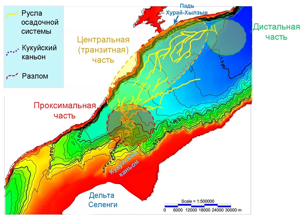
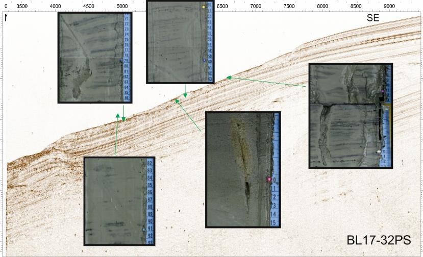
Сhannel complex of the Khuray sedimentary system (Соловьева и др., 2018). Bathymetry data according to (De Batist M., Channels M., Sherstyankin P., Alekseev S. & the INTAS Project 99-1669 Team, 2002. A new bathymetriс map of Lake Baikal. http://www.lin.irk.ru/intas/index.htm)
Sampling in the central part of the Khuraу sedimentary system targeted the channels and the levees. Granulometric analyses revealed the presence of coarser and thicker turbidite intervals inside the channels. Results also revealed that the channels in the proximal region contain coarser and more compacted sands compared to those from the distal part. Comparison between the collected cores allowed to establish a cross correlation of the turbidite events (Почевалова и др., 2016).

An example of turbidite laminae correlation between the cores collected during the Class@Baikal-2015 expedition in the Kuray deep-water depositional system. Coring sites location is on inset. Turbidites of southern channel are marked in yellow, turbidites from the north are in grey
Despite the wealth of data available, still remains unclear the source of terrigenous material and the evolution of the Khuraу sedimentary system during the Quaternary.
Class@Baikal-2018 Expedition objectives:
Sparker seismic profiles will be acquired during the expedition. One of the main goals will be to study the distal part of the system and the fan zone. Investigations will be conducted in the proximal and central areas of the system to refine the information regarding the structure, the morphology and the age of the system. Sampling will be conducted to obtain additional data about the sedimentary facies distribution and their sources.
References:
Ахманов Г.Г., Хлыстов О.М., Токарев М.Ю. и участники TTR-Class@Baikal-2014 (2014) Первая экспедиция Байкальского Плавучего Университета: современное осадконакопление и зоны фокусированной разгрузки углеводородов и газогидратообразования на дне озера // Cб. тезисов III Международной молодежной научно-практической конференции "Морские исследования и образование". – С. 19-23.
Ахманов Г.Г., Хлыстов О.М. и участники TTR-Class@Baikal-2015 (2015) Проект Glass@Baikal: развивая традиции Международной программы "Обучение-через-исследования (Плавучий Университет)" // Сб.: Труды IV Международной научно-практической конференции "Морские исследования и образование (MARESEDU)". – М.: Феория, 2015. – С. 29-33.
Батиметрические данные: Программа Президиума РАН 17.8 (2009) и FWO Flanders project 1.5.198.09 [электронный ресурс] — Режим доступа: http://lin.irk.ru/multibeam/ru
Соловьева М.А., Почевалова А.В., Ахманов Г.Г., Хлыстов О.М., Ченский А.Г. (2017) Результаты сейсмоакустических исследований глубоководной осадочной системы Хурай (оз. Байкал) // Сб. мат. Всероссийской научной конференции молодых ученых КИМО-2017. – Институт океанологии им. П.П. Ширшова РАН, 2017. – С. 526-527.
Соловьева М.А., Почевалова А.В., Ахманов Г.Г., Хлыстов О.М., Ченский А.Г., Токарев М.Ю. (2018) Результаты комплексирования геологических и геофизических методов исследования глубоководной осадочной системы Хурай (оз. Байкал) // Сб. мат. Всероссийской научной конференции молодых ученых КИМО-2018. – Институт океанологии им. П.П. Ширшова РАН, 2018. В печати.
Почевалова А.В., Ахманов Г.Г., Хлыстов О.М., Корост С.Р., Соловьева М.А. (2016) Конус выноса Хурай озера Байкал как современный аналог коллекторов глубоководного генезиса // Сб. тезисов Международной молодежной научной конференции Нефть и газ – 2016. — Т. 1. — РГУ нефти и газа им. И.М. Губкина, 2016. — С. 83-83.
Evangelinos D., C. Nelson H., Escutia C., De Batist M., Khlystov O. (2017) Late Quaternary climatic control of Lake Baikal (Russia) turbidite systems: Implications for turbidite systems worldwide // Geology. – 2017. – V. 45. – № 2. – P. 179-182.
Area 4. Underwater landslide «Krasnoyarskiy»
The underwater landslide later “Krasnoyarskiy” is located near the bottom of the delta slope of Selenga River. This feature was discovered using multibeam and echo-sounder methods during the RAS Program 17.8 (2009) and the FWO Flanders project (1.5.198.09). A systematic study of the landslide started in 2015 and continued during the last three Class@Baikal expeditions.
The data collected include seismic profiles (54 km), and bottom sampling (72 stations). The recovered sediments were studied at the MSU laboratories using multidisciplinary techniques including hydrocarbon gases geochemistry, engineering-geological measurements (penetrometer and micro-impeller), laboratory studies of the shear properties, X-ray tomography studies, computer modeling, etc. (Кудаев и др., 2017a).
The «Krasnoyarskiy» landslide is located at depths ranging between 300 and more than 700 m object and occupies a surface 10 km2. Small secondary landslide bodies can be observed within the primary landslide. The cored sediments reveal the typical slumped structures. The deformation of the clayey-diatom ooze Holocene interval indicates the recent activity of the slide.
TSlump structures in the sediments of Lake Baikal in the area of «Krasnoyarskiy» landslide (Кудаев и др.., 2018)
«Krasnoyarskiy» also displays a seepage area located at depth between 730 and 780 m. The focused fluid emissions were discovered in 2007. The combination of landslide process and fluid emissions may indicate that the instability of the slumped sediments is connected with their high gas saturation (Ахманов и др., 2015). This assumption is supported by the laboratory analyses and by the presence of degassing conduits observed in the cored sediments.
The channels of fluid filtration in the sediments of the body of the «Krasnoyarskiy» landslide (Кудаев и др., 2017a)
Channels of fluid migration typical for Baikal gas saturated sediments were found in Landslide deposits. Preliminary results of «Krasny Yar» landslide computer modelling confirm that relocated sediments were initially highly saturated with gas.
Class@Baikal-2018 Expedition objectives:
Preliminary results of numerical modelling of the landslide are consistent with a gas-saturated sediments scanario.
Class@Baikal-2018 Expedition objectives:
The 2018 Class@Baikal expedition aims to acquire additional data for a better understanding of the slope structure and its extension.
More precisely the following activities are planned:
• seismic profiles across the proximal side of the landslide. This data is necessary to study the possible paths of fluid migration from the hydrate bearing seep «Krasny Yar» towards the landslide area.
• bottom sampling in exposed scar region
• bottom sampling on the distal area of the landslide in order to define the specific structures of fluid migration in sediments.
References:
Ахманов Г.Г., Хлыстов О.М. и участники TTR-Class@Baikal-2015 (2015) Проект Glass@Baikal: развивая традиции Международной программы "Обучение-через-исследования (Плавучий Университет)" // Сб.: Труды IV Международной научно-практической конференции "Морские исследования и образование (MARESEDU)". – М.: Феория, 2015. – С. 29-33.
Кудаев А. А., Корост Д.В., Ахманов Г.Г., Хлыстов О.М. (2017а) Аутигенная минерализация в зонах фокусированной разгрузки углеводородов озера Байкал // В сб. Комплексные исследования Мирового океана. Материалы II Всероссийской научной конференции молодых ученых, г. Москва, 10-14 апреля 2017 г. [Электронный ресурс]. – Москва: ИО РАН – 2017а. – С. 478-479.
Кудаев А.А., Ахманов Г.Г., Хлыстов О.М., Корост Д.В. (2017b) Характеристика донных грунтов в зонах фокусированной разгрузки углеводородов озера Байкал // Материалы докладов XIII Общероссийской научно-практической конференции и выставки «Перспективы развития инженерных изысканий в строительстве в Российской Федерации». – 2017b. – С. 636-639.
Кудаев А.А., Ахманов Г.Г., Хлыстов О.М. (2018) Фокусированная разгрузка метана, как причина субаквального оползания склонов (на примере Красноярского оползня озера Байкал) // Материалы Международного молодежного научного форума «ЛОМОНОСОВ-2018» / Отв. ред. И.А. Алешковский, А.В. Андриянов, Е.А. Антипов. [Электронный ресурс] — М.: МАКС Пресс, 2018.
Хабуев А. В., Ченский Д.А., Соловьева М.А., Белоусов О.В., Кононов Е.Е., Хлыстов О.М. (2016) Оценка ресурсов газовых гидратов геофизическими методами в зоне подводной разгрузки газа на сипе «Красный Яр» озера Байкал //Известия Сибирского отделения Секции наук о Земле Российской академии естественных наук. Геология, разведка и разработка месторождений полезных ископаемых. – 2016. – №. 1 (54).
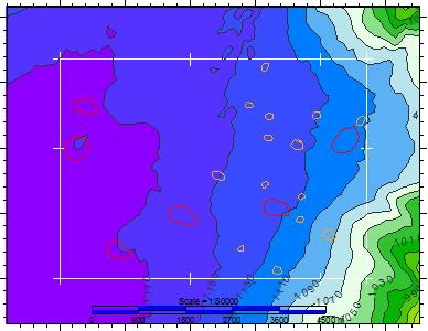
Area 5. «The Bolshoy» mud volcano
This area is located in the north-eastern part of Lake Baikal southernmost basin. “The Bolshoy” structure was discovered in 1999 during a joint Russian-Belgian geophysical expedition (van Rensbergen et al., 2002) and the sampling of mud breccia in 2003 (Khlystov, 2006), indicated that the structure is a mud volcano. Multibeam data indicate that Bolshoy mud volcano has a complex structure with a diameter of 1,1 km and two central pinnacles of 18 and 25 m (Cuylaerts et al., 2012).
Dedicated studies were conducted during the 2nd 3rd and 4th Class@Baikal expeditions collecting 15 acoustic profiles (total length 66 km) using the onboard profiler (i.e. KNUDSEN with frequency range from 1 to 10kHz and resolution around 0,1 m). Extensive bottom sampling for petrographic and geochemical (pore gas and gas hydrates) studies was performed.
Location of bottom sampling sites and subbottom profiler lines carried out during the Class@Baikal-2015 expedition in the Area «The Bolshoy» mud volcano
The new results reveal that the structure has in fact a base of is 800 m in diameter and that the two pinnacles have a height of 16 m (northern pinnacle) and 21 m (southern pinnacle) with freshly erupted mud breccia sampled in the proximity of the southern pinnacle.
Class@Baikal-2018 Expedition objectives:
A seismic survey with the sparker source will be conducted in order to collect new data about the structure of of «The Bolshoy» mud volcano. Bottom sampling will be carried out around the southern active area to collect sediments for geochemical and petrography analyses.
References:
Ахманов Г.Г., Хлыстов О.М., Поорт Дж, Токарев М.Ю., участники проекта Class@Baikal (2017) Проект TTR-Class@Baikal: итоги 4-х лет «Обучения-через-исследования» на озере Байкал // Труды VI Международной научно-практической конференции “Морские исследования и образование (MARESEDU-2017)”, серия Труды MARESEDU, Тверь, с. 221-224.
Василевская Я.А., Соловьева М.А., Буланова И.А., Ахманов Г.Г., Хлыстов О.М. (2018) Морфология грязевого вулкана Большой (оз. Байкал) по данным картирования с акустическим профилографом. // Материалы Международного молодежного научного форума «ЛОМОНОСОВ-2018» / Отв. ред. И.А. Алешковский, А.В. Андриянов, Е.А. Антипов. [Электронный ресурс] — М.: МАКС Пресс, 2018.
Хлыстов О.М. (2006) Новые находки газовых гидратов в донных осадках озера Байкал // Геология и Геофизика. 2006, Т. 47, № 8, с. 979-981.
Cuylaerts M., Naudts L., Casier R., Khabuev A.V., Belousov O.V., Kononov E.E., Khlystov O.M., De Batist M. (2012) Distribution and morphology of mud volcanoes and other fluid flow-related lake-bed structures in Lake Baikal, Russia. // Geo-Marine Letters. 2012, v. 32, № 5, pp. 383-394.
van Rensbergen P., De Batist M., Klerkx J., Hus R., Poort J., Vanneste M., Granin N., Khlystov O., Krinitsky P. (2002) Sublacustrine mud volcanoes and methane seeps caused by dissociation of gas hydrates in Lake Baikal. // Geology. 2002, v. 30, № 7, pp. 631-634.